AIMS monitors the Great Barrier Reef through two major programs - the Long-Term Monitoring Program (LTMP) and the collaborative Great Barrier Reef Marine Monitoring Program for inshore coral reefs (known as MMP).
Our monitoring is designed to detect changes in reef communities at a number of scales, including:
- individual reefs
- shelf position (inner, mid- and outer)
- latitudinal sector
- sub-region (shelf position in a latitudinal sector)
- regional (northern, central and southern Great Barrier Reef)
- and between management zones (i.e., open and closed to fishing).
AIMS reef monitoring programs use Standard Operational Procedures to ensure consistent methodology through time. This ensures that the data we are reporting on has been collected in a consistent, rigorous way, enabling robust appraisal of any changes in reef condition indicators through time. The methods used are globally accepted by the scientific community.
Reef surveys involve three approaches:
- Manta tow surveys of reef-wide coral cover, crown-of-thorns starfish numbers, amount of coral bleaching, numbers of coral trout and sharks
- Fixed site surveys of the animals and plants on the coral reef surface using photography
- Fixed site surveys of reef fish, juvenile corals, crown-of-thorns starfish, coral-eating snails and coral disease and bleaching using visual counts.
The Great Barrier Reef Marine Monitoring Program (MMP) for inshore corals is designed to detect changes in reef communities adjacent to the Wet Tropics, Burdekin, Mackay, Whitsunday and Fitzroy Natural Resource Management Regions.
Sampling areas
The core survey reef sample comprises two components:
- Manta tow surveys, which collect information in a standard reef slope habitat around the perimeter of each reef (for Long-Term Monitoring Program only)
- Fixed site surveys, in which reef fish and animals and plants on the reef surface are surveyed at three sites, in a habitat that is standardised across reefs.
In inshore waters, higher turbidity means that neither the manta tow nor fish surveys are included in the Marine Monitoring Program (MMP). This high turbidity means that coral communities can be very different at different depths and reefs are also less extensive. For these reasons, the sampling design of the MMP includes sampling at two depths, 2m and 5m at only two sites. The length of the five transects at each site is also reduced to 20 m.
Manta tow surveys
AIMS began manta tow surveys of the Reef in the early 1980s. These surveys were incorporated into the Long-Term Monitoring Program in 1992. Manta tow surveys cover reefs in 11 latitudinal sectors.
The manta tow technique is used to provide a general description of large areas of reef and to gauge broad changes in abundance and distribution of organisms on coral reefs.
Manta tow surveys:
- detect and monitor populations of crown-of-thorns starfish
- provide estimates of percentage cover of living hard corals, living soft coral and recently dead hard coral
- allow an assessment of the impact of crown-of-thorns starfish outbreaks and other large-scale disturbances such as the percentage of corals fully bleached
- record the numbers of coral trout and sharks that are encountered.
Manta surveys hold certain advantages over other reef survey techniques:
- They enable large areas of reefs to be surveyed quickly and with minimal equipment
- They can be conducted at both low and high tides
- They survey a standard, biodiverse reef habitat to allow robust comparisons between reefs and the same reef over time.
Manta tow sampling
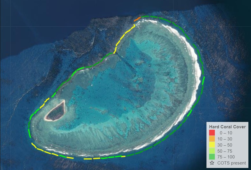
The percentage of the reef slope around the entire perimeter of each reef that is covered with living hard and soft coral and dead hard coral is calculated from the manta tow surveys.
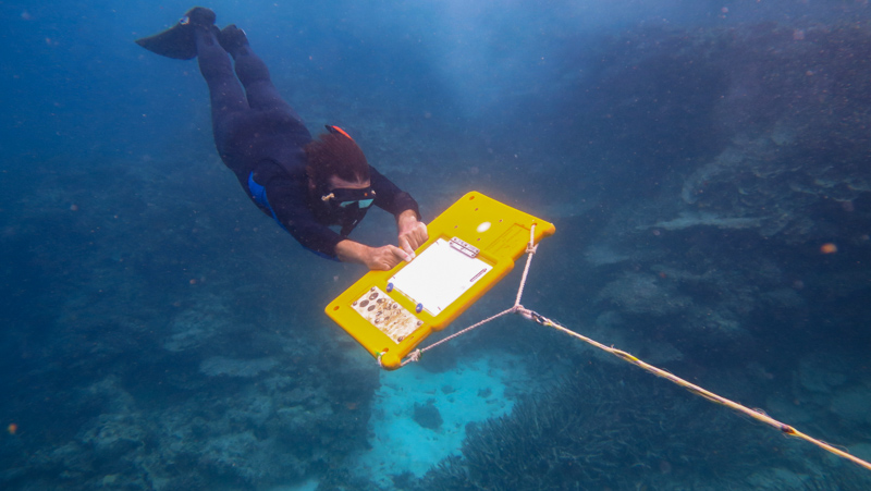
The technique involves towing a snorkel diver (observer) at a constant speed behind a boat in a series of two-minute tows. The observer holds on to a manta board attached to the boat by a 16-metre length of rope. The observer makes a visual assessment of specific variables on the reef slope during each two-minute manta tow and records these data on a data sheet attached to the manta board when the boat stops.
Results from manta tow surveys
Estimates of percent coral cover from each survey reef are the average of all the tows conducted at a given reef. Similarly, estimates at broader spatial scale (e.g., latitudinal sector, NRM region) are the average of all tows conducted within the sector or region. The hierarchical sampling design requires the use of complex statistical modelling techniques that account for this design.
The average number of the crown-of-thorns starfish per tow are used to assess the outbreak status of each reef.
There are four outbreak categories, described below. In 2024, AIMS updated its COTS category names to reflect those of the Great Barrier Reef Marine Park Authority.
| Crown-of-thorns starfish category | Number of COTS per tow |
|---|---|
| Severe outbreak (formerly Active) | >1 |
| Established outbreak (formerly Incipient) | 0.22 to 1 |
| Potential outbreak | 0.1 to 0.22 |
| No recent outbreak | <0.1 |
Results from manta tow surveys can be viewed at the Reef Dashboard.
For more detailed information see Standard operational procedure number 9.
Fixed site surveys
Fixed site surveys are designed to detect reef community changes in more detail and at finer taxonomic resolution than what can be provided by manta tow surveys. These surveys provide detailed information on changes to coral and reef fish assemblages in a standard reef slope habitat, that enables robust spatio-temporal comparisons among reefs across the continental shelf and from the norther to southern GBR. Ensuring each site is permanently marked helps reduce variation in the data due to sampling, and enables us to detect changes through time, which is the primary goal of monitoring.
Methods
In fixed site surveys, the standardised habitat is in the first stretch of continuous reef slope (excluding vertical drop-offs) encountered when following the perimeter from the back reef zone towards the front reef in a clockwise direction, usually on the north-east flank of the reef.
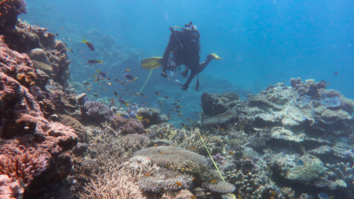
Sites are at least 250 m apart where possible. Within each site, five 50 m transects are laid along the reef slope parallel to the reef crest at about 6-9 m depth. Transects are marked with a star picket and with lengths of reinforcing rod at 10 m intervals. Reef fish and animals and plants on the coral reef surface are surveyed on five permanently marked transects within each of three sites per reef using digital imagery for corals and plants, and underwater visual surveys for reef fishes, juvenile corals and agents of coral mortality (i.e. crown-of-thorns starfish, coral bleaching and coral disease).
Between 1992 and 2006, 45 reefs were surveyed annually as per the original LTMP sampling design.
From 2006 to 2021 the original set of reefs were surveyed every second year (in odd-numbered years) while a second set of reefs chosen to assess the effect of the 2004 Great Barrier Reef Marine Park re-zoning plan was surveyed in the alternate (even-numbered) years.
Starting in 2022, 72 LTMP core reefs are surveyed every year, although there have been changes to the sampling design.
Inshore reefs surveyed as part of the MMP are also surveyed every second year, although are sometimes visited annually to document the effects of large disturbances such as coral bleaching or cyclones.
Photographic surveys
Holding digital still cameras approximately 40 cm above the substrate, the scientists take 70 photographs at approximately regular intervals along each transect. Percentage cover of corals and other benthic categories are estimated from five points on each image on 40 images, so 200 systematically dispersed points are sampled from each transect.
The MMP uses the same sample methods. However, because of the smaller area of many inshore reefs, sampling is compressed so that 40 photographs are taken at 50cm intervals along each transect.
On returning from fieldwork, images are run through an Artificial Intelligence (AI) algorithm, which gives a first pass estimate at the percent hard coral cover and coral identification. The results from the AI are then cross checked by human observers before estimates of hard coral cover for the different groups of coral are finalised. The development of the AI is part of AIMS’ dedication to continual improvement in the collection and reporting of coral reef monitoring data.
For more detailed information see Standard operational procedure number 10.
Counts of reef fishes during fixed site surveys
Fish species are counted on the five 50 m transects in each of three sites at each reef. All species are largely non-cryptic (‘cryptic’ fish are fish that are often hard to see, for example because they hide or are camouflaged) and are easily identified underwater. They include commercial and non-commercial fish.
The surveys span the annual recruitment season, so fish less than one year old are excluded from counts. These are distinguished by their small size and often distinctive colouration. This is to reduce excessive variability in counts as fish less than one year old can appear in huge numbers shortly after they settle onto the reef but can then suffer enormous mortality in the next year. Large, mobile fish are counted using a 5 m wide belt transect, while damselfishes and other small-bodied fishes (e.g. some wrasses) are counted separately on transects 1 m wide. The lengths of all fishes are estimated visually.
The general survey procedure at each site involves an experienced observer swimming along the transect line counting large mobile fishes to a distance of 2.5 m either side of the mid-line. An assistant swims behind the observer and lays a surveyor's tape over the substratum along the centre line of the transect. When large, mobile fish have been counted on the five transects of a site, an observer returns along the same transects (now marked with a tape along the centre line) and counts damselfishes and other small fishes on a transect 1 m wide.
For more detailed information see Standard operational procedure number 3.
SCUBA searches during fixed site surveys
SCUBA searches are designed to provide a more detailed picture of the causes of coral mortality than is possible with either the manta tow technique or the video technique. SCUBA searches are made on the permanently marked transects. A 2 m belt (1 m either side of the central tape measure) is visually searched along each 50m transect (or 20m for the MMP), and numbers are recorded for the following:
- crown-of-thorns starfish,
- scars caused by that starfish,
- Drupella species (coral-feeding snails),
- Drupella species scars,
- white syndrome coral disease,
- black band coral disease
- and unknown scars.
An estimate of coral bleaching as a percentage of live coral cover is also recorded.
For more detailed information see Standard operational procedure number 9.
Counts of juvenile hard corals during fixed site surveys
Recruitment is a basic demographic process and counts of juvenile hard corals are helpful for predicting how coral communities may change in following years.
Juvenile hard corals that are defined as colonies that measure less than 5cm diameter. Since 2007, these juveniles have been counted in a belt 34 cm wide (length of dive slate) along the first 5 m of each transect. The MMP counts juvenile corals in a 34 cm wide belt along the full 20 m of each of their transects.
Standard Operational Procedures
These operational procedures detail the methods used by the reef monitoring teams at AIMS to survey coral reefs communities along the Great Barrier Reef.
| SOP | Year | Title |
|---|---|---|
| SOP 02 | 2004 | Surveys of benthic reef communities using underwater video |
| SOP 03 | 2018 | Visual census of reef fish |
| SOP 04 | 1999 | Field and analytical techniques for the collection of marine sediments |
| SOP 05 | 2000 | A guide to the reef monitoring database |
| SOP 06 | 2000 | Water quality - field and analytical procedures |
| SOP 08 | 2020 | SCUBA search technique: Surveys of agents of coral mortality |
| SOP 09 | 2019 | Crown-of-thorns starfish and coral surveys using the manta tow technique |
| SOP 10 | 2008 | Surveys of benthic reef communities using underwater digital photography and counts of juvenile corals |
| SOP 10 | 2020 | Surveys of benthic reef communities, using underwater digital photography and counts of juvenile corals – Edition 2 (2020) |
| SOP 11 | 2022 | Aerial surveys of coral bleaching |
| SOP 12 | 2020 | 3D habitat reconstructions of benthic communities |
| SOP 13 Ed1 | 2025 | Long-Term Monitoring Program Survey Sampling Design - Edition 1 |
| SOP 13 Ed2 | 2025 | Long-Term Monitoring Program Survey Sampling Design - Edition 2 |
| SOP 14 | 2023 | Field Photogrammetry in 4D: field workflow and data collection |
| SOP 15 | 2024 | ReefScan Transom |
| SOP 16 | 2025 | Field photogrammetry in 4D: model processing |


