
Data & Publications
What is the AIMS Data Platform
The AIMS Research Data platform is a ‘research and development network’ driving solutions in new research in Australia’s Marine and Coastal ecosystems. It encompasses next-generation sensors, artificial intelligence, robotics, autonomous systems and cloud computing to provide more comprehensive knowledge, faster, to inform sustainable management.
The platform includes the data repository (catalogue), data tools (time series explorer, weather app, etc), and web service protocols. Lead by the Data Systems Engineering team, the platform was launched in 2020.
The AIMS Data Platform modernizes the provision of data streams, providing agility in the use of data, data collection technologies and exploratory data analysis environments. The platform consolidates data management functions across datasets, providing flexibility and innovation potential. Using new developments in data science, big data, cloud infrastructure and machine learning to provide support for emerging high volume data collection and the analysis of these
How to use the AIMS Data Catalogue
The AIMS Data Catalogue contains the metadata records describing the institute’s data holdings. The catalogue is searchable in several ways:
- Keyword Search
- Spatial filters with the map extents
- Temporal filters using a slide bar
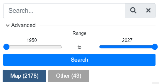
Keyword Search results lists appear in the scroll list under tabs Map, or Other:
- Search results with no spatial extent are displayed on ‘Other’ tab
- Search results with spatial extents are displayed on ‘Map’ tab
- Number of search results are displayed next to each tab heading. Total Map results with change when zooming in and out of Map (results are spatially filtered)
- each search result is hyperlinked to open a new page (preserving search criteria on original page)
- Spatial extents of each search result is displayed when hovering over title
- Map drop point toggle to right of each title to zoom into map
- Scroll through search results with vertical scroll bar to right of each title
Interactive Map features on the search page include:
Zoom – zooming in or out of the map will alter the search results (as spatially filtered). The Zoom buttons are located at the top right of the map, and reset zoom located next o the keyword search box
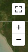
[Zoom In (+) /Out (-) buttons]
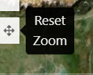
[Reset Zoom]
Interactive map toggles (yellow) will aggregate spatial points when zooming in or out. Changing the map view will result in the aggregated points redistributing in appropriate collections. Clicking on a Yellow toggle will cause the map to zoom into the area.
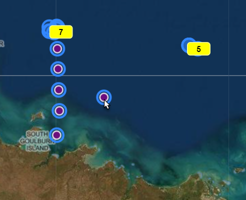
Purple map points display a single point. When hovering over the map points, any related points will also highlight.
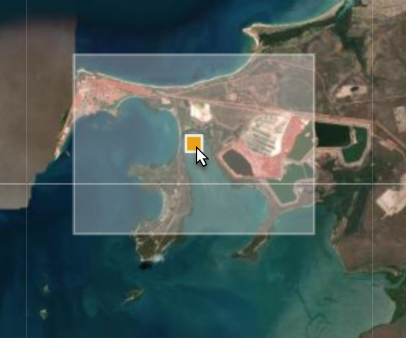
Orange square points represent an area (bounding box)
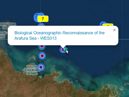
Clicking on the orange or purple map points will open a text box with a title of the data record associated with that point. The title is hyperlinked, and will open a new page to the data record when clicked on.
Real Time Data Streams
Some data are real time data streams, collecting and updating data in up to 10 minute intervals.
These data are found in the Weather Stations App and the Time Series Explorer App, as well as through metadata records which describe the details of the deployments, instrumentation, and display data summary charts.
See the program metadata record for details: Northern Australia Automated Marine Weather and Oceanographic Stations, https://doi.org/10.25845/5c09bf93f315d.
Outages/gaps in data of weather stations can be due to:
- Extreme weather events damaging equipment. Equipment may be offline for some time following an extreme weather event, while maintenance is ongoing.
- Decommissioning of mooring or weather stations due to end of funding
- Equipment failure requiring maintenance
These data are also available through developer tools
Contact
Email adc@aims.gov.au for any help or queries about the data pages. Please also see the point of contact on each metadata record.