How the Great Barrier Reef was formed
Present time
The outer Great Barrier Reef
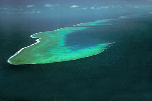
As we have seen, corals and reefs grow best where there is most water movement. As the coastal plain became flooded, the most energetic region was at its outer edge. This is why the outside edge of this old coastal plain (the continental shelf) tends to be outlined by a line of reefs. In the north of the Great Barrier Reef, these outer reefs tended to form as ribbons along the edge of the continental shelf. The ribbons can be many kilometres long but there has to be occasional gaps to allow tides to flow in and out across the shelf.
Aerial view of Yonge Reef, and other ribbon reefs, in the north of the Great Barrier Reef.
The front of this reef drops sharply down the edge of the continental shelf. The edge of the continental shelf drops to the floor of the Coral Sea, about 2000 metres below sea level.
The reefs in the photograph above are called ribbon reefs because of their distinctive shapes.
Why are there inner and outer reefs instead of one big outer reef?
Because the coastal plain wasn't flat. The coastal plain included river valleys and small and large hills. Corals tended to grow best on hills because they were where waves broke and the water was most turbulent. Thus, although corals probably grew on any available hard shallow surface on the flooding coastal plain, reefs tended to form where there were hills.
Cross section of coastal north Queensland at the present time
Sea-level in the past 20,000 years has risen approximately 120 meters to the present level.
The outer reefs started as fringing reefs along the edge of the continental shelf, (as illustrated by the image of Ningaloo Reef on the coast of western Australia). Remember what happened to the hills? The inner reefs are mostly the tops of these small hills that once had fringing reefs and like the outer reefs, the growing coral eventually completely covered them as the sea level rose.
If the sea level continues to rise at a rate that coral growth can keep up with it, then over thousands of years the fringing reefs around the continental islands will eventually grow to cover these islands in coral, if this should happen, the coastline of Australia will look very different indeed.
Sand cays
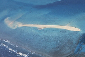
Sand cays usually don't form on the outer reefs because of high wave action, but as the photograph below shows, there are exceptions.
A Sand Cay on an outer reef viewed from the air.
Deep water and the reef face are at the lower left with the reef flats tapering into a lagoon at the upper right of the photograph.
Birds, wind and currents carry seeds to the cay and, with time, it becomes vegetated.
Sand Cay forming on the reef face side of a coral reef.
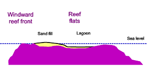
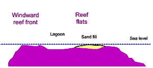
Sand Cays are formed when wave and tidal action deposit coral rubble and sand onto reef flats. The sand cay in the photograph above is unusual in that it has formed near to the windward side of the reef instead of on the leeward side. This is probably because waves and currents collide at this point and cause sediment to fall out of the water.
Figure 6: Cross section of a reef showing a sand cay forming on the windward side.
Sand cays are more frequent on inner reefs of the Great Barrier Reef where waves and currents are less strong than on reefs further out.
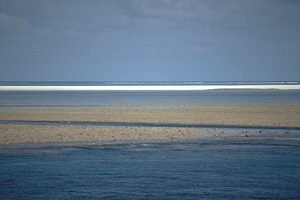
A sand cay viewed from sea level.
The windward side of the reef is out of view in the far distance. (This reef is several kilometres across.)
A shallow reef lagoon separates the windward reef from the cay (the white band of sand in the middle of the photograph). The leeward reef is in the foreground.
Sand cay forming on the rear side of a reef flat.
Cays most usually form on the leeward side of reefs.
Figure 7: Cross section of a reef showing a sand cay forming on the leeward side.
March 19, 2010


